Blog in Polish/po polsku: http://ontario-nature-polish.blogspot.ca/2012/08/na-kanu-po-rzece-key-river-i-zatoce.html
There are certain places so special, so beautiful and so delightful that one is never bored with them and is always looking forward to visiting them again. For me, such places are French River Provincial Park and the area around Philip Edward Island. In August, 2012, I was fortunate to visit both locations during an almost 2 week-long excursion and indeed, I again feel like going there once more!
This blog covers the first leg of the trip (Key River-Georgian Bay-French River Provincial Park), in the next blog I wrote about the other part of the trip, when we spent one week canoeing and camping in the vicinity of Philip Edward Island (http://ontario-nature.blogspot.ca/2012/08/canoeing-on-georgian-bay-south-of.html).
I have already lost count as to the number of visits I have made to French River Park since 1995, but I have probably paddled there no less than ten times. It would take weeks, if not months, to leisurely explore this region, stretching from Lake Nipissing to Georgian Bay, with all its rivers, tributaries, outlets, bays, islands, pools and rocky shores. Hence, there are still quite a few places that I have not paddled on. The Key River, which forms a natural border in the south of the park, was one of them. The Key starts about 3 kilometers east of Highway 69 and allows watercrafts an easy and portage-free access to Georgian Bay (about 14 km). And since I have never visited that particular part of Georgian Bay (most of which belongs to the park), I was anxiously looking forward to this trip.
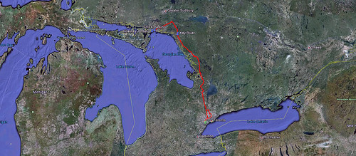 |
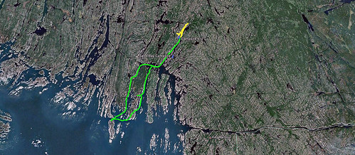
| Driving from Toronto to Key River Marina and the town of Killarney |
On Monday, August 13, 2012, we left Toronto early in the morning, expecting to arrive at the Key River Marina before noon. It was a smooth drive up north and we made it on time. Having paid in advance for parking until Saturday, we transferred our camping equipment from the car to the canoe (as usually, attracting some attention from onlookers, somehow startled by the large size and the quantity of our belongings) and were on the water just after noon. All this time we saw motor boats—there were cottages/resorts on the river, around the mouth of the river as well as on Georgian Bay or the French River. The Key River made the perfect access route to them. Nevertheless, we did encounter merely a fraction of the motor boat traffic we had expected and most of the time we paddled without having to watch the passing boats.
 |
| Key River Marina--we are ready to set out on our trip! |
After about 20 minutes we left behind the marinas and the road traffic rushing on the highway bridge. The south side of the river belonged to an Indian Reserve (Henvey Inlet First Nation) and there was only one dwelling, apparently belonging to a denizen of this reserve; otherwise we did not see any structures. The north shore was part of French River Provincial Park, yet there were occasional cottages on private patches of land. Since the Key River was created as a result of a geological fault line, it was very straight and easy to paddle on. Both shores were quite picturesque and very rocky, yet the north shore was noticeably higher and the rock face more precipitous than the opposite shore, probably as a result of various geological processes. Well, I often regret I know so little about geology, as this area (part of the Canadian Shield, Canada’s largest physiographic area) comprises of many remarkable geological features—in addition to Precambrian rocks that are over 570 million years old, there are plenty of glacial features. It was glacial activity that helped to form the basins and paths of many scenic lakes and rivers. As a consequence, a uniquely characteristic landscape was formed, with very thin soil lying on top of the bedrock, with many bare outcrops. Although not suitable for farming (not that it was not endeavoured in the past, yet in most cases, after inestimable drudgery, sweat and tears on the part of farmers, it came to nothing), it attracted numerous tourists, hunters, fishermen and artists. Some of them were the painters who formed the famous Group of Seven and produced hundreds of outstanding paintings which exceptionally depicted the rugged beauty of this region.
 |
| After departing from Key River Marina, we paddled on the Key River and once we reached Georgian Bay, we paddled north and set up our campsite on lovely site #912 on Sand Bay |
There was one official campsite on the Key River, but we only guessed its location thanks to my GPS—there was no official sign. We stopped for lunch halfway our trip and after another 2 hours of paddling, dwellings started to appear on both shores (which, at that point, did not belong to the park or the reserve). In fact, it would be probably possible to find a nice campsite on the south shore of the river—most likely it was crown land—but we wanted to stay somewhere on Georgian Bay. Just before 04:00 pm we reached the mouth of the Key River, where quite a few houses stood along the shores. Well, after all, it was the former village of Key Harbour!
 |
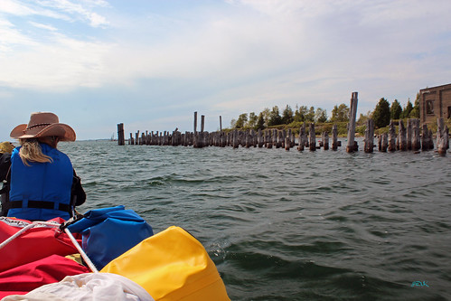
| Ruins of the old generating plant and rotting dock supports |
In 2009 and 2010 we had canoed on the Pickerel River (also part of French River Park) and reached a railway bridge (http://ontario-nature.blogspot.ca/2010/08/pickerel-river-canoeing-july-august.html). There were several houses clustered near the CN bridge. It was Pickerel River, once a small, but thriving community, with stores and a train station—nowadays another ‘ghost town,’ accessible only by water, inhabited by cottagers in the summer and virtually deserted in the winter. Just 2.5 km south of this former town was a tiny community of Key Junction (today a ‘real’ ghost town): in 1908 a spur line was built, linking the main railway at Key Junction with the harbour—yes, Key Harbour! A port was built, with a 300+ m dock which could support trains. For almost ten years, the newly discovered ore deposits near Sudbury, Ontario, were transported by train via Key Junction to Key Harbour and then shipped to the USA on Great Lake freighters. Unfortunately, the new, bigger freighters had problems navigating in the harbour, so the ore shipments were transferred to Depot Harbour (near Perry Sound)—by the way, Depot Harbour has been a ghost town since 1979. However, the Key River harbour remained active for the next 20 years, this time used to ship coal that arrived on freighters from the USA, then was off-loaded and shipped by trains, mainly to be used in steam engines. About 1938 coal shipments diminished as more and more engines were using diesel. For another 20 years the harbour was used to transport mainly fish and passengers, but the end was inevitable and eventually came in the early 1960s, when the line was abandoned and the tracks were lifted.
 |
| Key Harbour Lodge at the mouth of the Key River |
We briefly stopped at Key Harbour Lodge, which offered accommodation, fishing supplies, boat rentals, some food and also sold park permits. The owner told me that the spur line (which used to run meters behind the lodge) was overgrown and barely visible (some parts are still discernible on satellite Google maps) and he used it when bear hunting. Nearby were the ruins of half-standing powerhouse along with rotting dock supports, still attesting to the long, massive and strong dock that once was the hub of shipping activity, used by both ships and trains.
 |
| After passing the ruins of the old dock, we reached the open waters of Georgian Bay |
Unfortunately, we did not have the time to explore this interesting place. Once we left the mouth of the river, we were on the open waters of unpredictable Georgian Bay. While paddling on the river, we did feel the wind, but it was not just a minor nuisance. Now the same rather mild wind seemed much stronger—suddenly we had to struggle with moderate waves that were high enough to rock our canoe. Initially, I wanted to paddle west or northwest, pass the north tip of Dead Island and then start looking for a campsite in one of the numerous inlets (or maybe even stay on the campsite on Finger Island, where our group camped in September, 2008—see http://ontario-nature.blogspot.ca/2010/06/french-river-trip-september-4-9-2008.html) Yet this route would require paddling across almost open water, exposing to the wind and waves, with almost no shore or rock nearby to take refuge on. Soon I realized that the farther west we were paddling, the rougher it became—a bunch of fishermen, in a much bigger motorboat, were looking at us with curiosity, perhaps making bets on how long we were going to last! There was nothing else to do but make a sharp turn north and paddle towards Dokis Island, Sand Bay and Pickerel River. We paddled to the right of Germain Island, then reached Whistler Bay, passed the northern tip of Puddick Island and entered Sand Bay. Some of the islands in the area—especially the quite large Dokis Island—were either private (with a couple of cottages scattered here and there) or still constituted crown land, free to camp on! Sand Bay turned out to be very picturesque, with several long islands and rocky shores. About half an hour later we started looking for campsite #912, the only one in this area. Eventually we did spot a place that could make a good campsite (again, thanks to my GPS unit), but we did not see any ‘official’ sign. We paddled into a small bay and went ashore.
 |
| Our scenic campsite no. 912 on Sand Bay (N45 56.516 W80 44.594) |
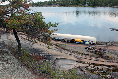
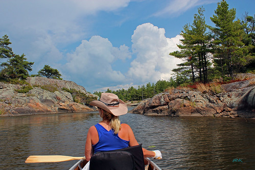
Although we never saw any sign, it was certainly the campsite! There were a couple of fire pits—sadly, there was also a lot of broken glass all over the campsite (mainly from broken beer bottles—the next day I found a piece of the beer bottle bottom, with sharp glass pieces sticking out) and plenty of cigarette butts. A few primitive, patched up ‘furniture’ turned out to be very convenient—Catherine loved the table made from an old barbecue stand (in fact, she loved the site with a serendipitous bay on the other side)—and nearby was a crude latrine, with a real toiled seat—the problem was that its location was much too close to the center of the campsite to be used! The campsite was located on a long rocky peninsula, so on the other side was a small bay, partly dry—the water level this summer was very low as it had not rained for some time. There were blueberry bushes all over, but totally burned by the sun, literally rust colored shrivelled leaves with no berries. On the opposite shore of Sand Bay was a solitary, unoccupied green cottage. Soon I pitched the tent and Catherine unpacked the canoe and set up the kitchen. We were tired—after all, that day we drove well over 300 km and paddled 21 km. I was thirsty and had two cans of cold beer, later went fishing in the tiny bay where our campsite was located. Just in case, we hanged our two barrels on the tree. There were plenty of firewood everywhere and once it became dark, we had a campfire, grilled a couple of steaks and went to bed relatively early.
Georgian Bay is a large bay of Lake Huron, covering over 15,000 square kilometers (5,800 sq miles), making it almost as large as Lake Ontario and it is often called ‘the sixth great lake’.
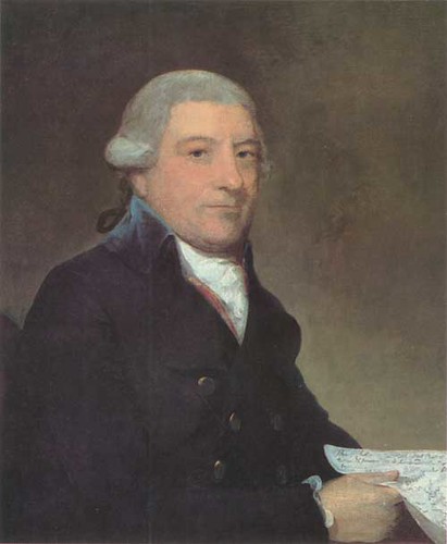
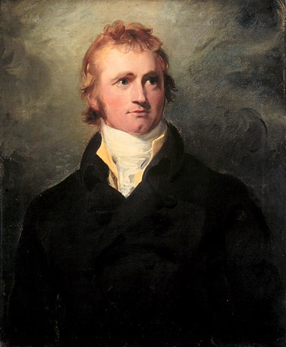
The first Europeans to see Georgian Bay were Étienne Brûlé, who probably reached it in 1610 and later the famous explorer Samuel de Champlain, who travelled from Lake Nipissing via the French River to Georgian Bay in 1615. He was the first European to map this area, calling the bay “La Mer Douce” (the Calm Sea).
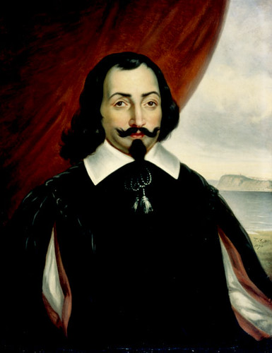 |
| Samuel de Champlain |
This is how Samuel de Champlain described his journey, after leaving Lake Nipissing and heading south:
“After resting two days with the chief of the Nipissings we re-embarked in our canoes, and entered a river, by which this lake discharges itself [French River]. We proceeded down it some thirty-five leagues [one league was from 3.25 km to about 4.68 km], and descended several little falls by land and by water, until we reached Lake Attigouautan [Georgian Bay/Lake Huron]. All this region is still more unattractive than the preceding, for I saw along this river only ten acres of arable land, the rest being rocky and very hilly. It is true that near Lake Attigouautan [Georgian Bay/Lake Huron] we found some Indian corn, but only in small quantity. Here our savages proceeded to gather some squashes, which were acceptable to us, for our provisions began to give out in consequence of the bad management of the savages, who ate so heartily at the beginning that towards the end very little was left, although we had only one meal a day. But, as I have mentioned before, we did not lack for blueberries and strawberries; otherwise we should have been in danger of being reduced to straits.”
Champlain also met a lot of Indians:
“We met three hundred men of a tribe we named “Cheveux Relevés” [this significant name is given with reference to their mode of dressing their hair], since their hair is very high and carefully arranged, and better dressed beyond all comparison than that of our courtiers, in spite of their irons and refinements. This gives them a handsome appearance. They have no breeches, and their bodies are very much pinked in divisions of various shapes. They paint their faces in various colors, have their nostrils pierced, and their ears adorned with beads. When they go out of their houses they carry a club. I visited them, became somewhat acquainted, and formed a friendship with them. I gave a hatchet to their chief, who was as much pleased and delighted with it as if I had given him some rich present. Entering into conversation with him, I inquired in regard to the extent of his country, which he pictured to me with coal on the bark of a tree. He gave me to understand that he had come into this place for drying the fruit called “blués” [blueberries] to serve for manna in winter, and when they can find nothing else.”
After two days Champlain continued south along the shores of Georgian Bay, he noted the numerous islands and abundant quantities of excellent fish:
“The next day we separated, and continued our, along the shore of the lake of the Attigouautan [Georgian Bay/Lake Huron], which contains a large number of islands. We went some forty-five leagues, all the time along the shore of the lake. It is very large, nearly four hundred leagues long from east to west, and fifty leagues broad [actually, Georgian Bay is about 220 kilometers (140 miles) long by 100 kilometers (62 miles) wide; lake Huron has a length of 332 km (206 miles) and a greatest breadth of 295 km (183 miles)], and in view of its great extent I have named it the “Mer Douce” [the Calm Sea]. It is very abundant in various sorts of very good fish, both those which we have and those we do not, but especially in trout, which are enormously large, some of which I saw as long as four feet and a half, the least being two feet and a half. There are also pike of like size, and a certain kind of sturgeon, a very large fish and of remarkable excellence. The country bordering this lake is partly hilly, as on the north side, and partly flat, inhabited by savages, and thinly covered with wood, including oaks. After crossing a bay, which forms one of the extremities of the lake [it was Matchedash Bay in Simcoe County in Central Ontario. It is the final inland extension of Severn Sound on Lake Huron's Georgian Bay], we went some seven leagues until we arrived in the country of the Attigouautan at a village called “Otoéacha”, on the first day of August [1615].”
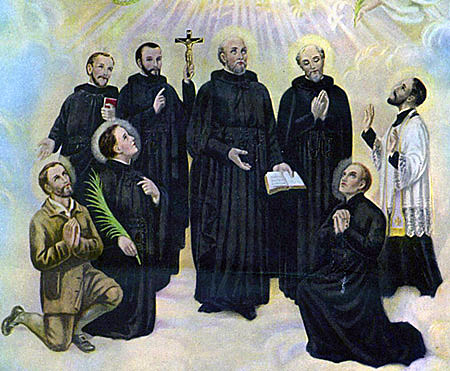 |
| The Canadian Martyrs |
Just 11 years later (in July, 1626) Jesuit priest Jean de Brébeuf travelled by canoe 800 miles from Quebec to the Huron territory along the same route to the West, via Lake Nipissing and the French River to Georgian Bay, where he founded the Huron mission and eventually was martyred there in 1649. He was canonized in 1930 with seven other missionaries, known as the North American Martyrs or Canadian Martyrs.
Edwin John Dove Pratt (1882-1964), one of the leading Canadian poets of his time, wrote a long epic “Brébeuf and his Brethren” on the mission of Jean de Brébeuf and his seven fellow Jesuits (the North American Martyrs) to the Hurons, their founding of Sainte-Marie-among-the-Hurons and their eventual martyrdom by the Iroquois.
Below are some of the verses of his poem that describe Brébeuf’s first journey to the Hurons:
So the flotilla started—the same route
Champlain and Le Caron eleven years
Before had taken…
............................
............................
To the blue waters of the Nipissing,
And then southward a hundred tortuous miles
Down the French River to the Huron shore.
The record of that trip was for Brébeuf
A memory several times to be re-lived;
Of rocks and cataracts and portages,
Of feet cut by the river stones, of mud
And stench, of boulders, logs and tangled growths,
Of summer heat that made him long for night,
And when he struck his bed of rock—mosquitoes
That made him doubt if dawn would ever break.
‘Twas thirty days to the Georgian Bay…
 |
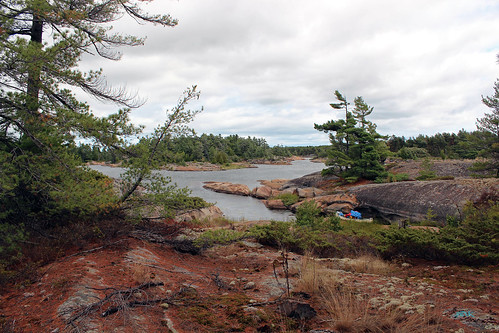
| Our favorite site, near the long, narrow rocky channel on the other side of the campsite |
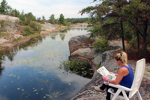
Next day the weather was so-so, it was windy and we remained at the campsite, enjoying reading books, newspapers and magazines. Later three motorboats showed up, their occupants got out on a rocky outcrop nearby and after a few hours drove off. We went paddling in the evening. According to the map, the northern part of Sand Bay was very narrow and then there was a creek, leading to a marshy area with intermittent water—and also to the old Key Junction spur line (or its remaining right-of-way).
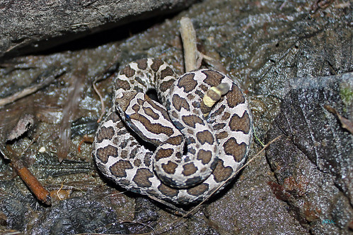 |
| The Eastern Massasauga Rattlesnake |
 |
| The Eastern Massasauga Rattlesnake, the only venemous snake in Ontario |
According to the marine weather forecast, the weather was supposed to be nice on August 15, 2012 and we decided to explore Georgian Bay and adjoining islands.
Let me now go back in time some 170 years…
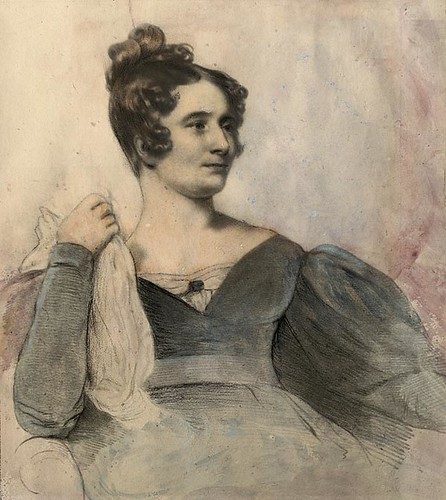 |
| Anna Brownell Jameson (1794-1860) |
In 1836 Anna Brownell Jameson (1794-1860), a British writer, arrived in Canada (Upper Canada) to join her husband who was soon to become the first Vice Chancellor of the Court of Equity in the province. She spent the next year travelling to such places as Niagara, Hamilton, Woodstock, London, the Talbot Country, Detroit, Mackinaw Island; she also traveled, mainly in a canoe, from Sault Ste. Marie to Toronto, visiting such places as Manitoulin Island and the site of town of Killarney, as well as along the shores of Georgian Bay, just south of Philip Edward Island and near the mouth of the French River. During her extensive travels she was thrown “into scenes and regions hitherto undescribed by any traveler and into relations with the Indian tribes such as few European women of refined and civilized habits have ever risked and none have recorded”. The result was her book titled “Winter Studies and Summer Rambles in Canada”, published after her return to England. This book gives a very vivid picture of the area, people and customs of the time.
This is what she wrote as she was canoeing near the mouth of the French River, or Rivière des Français:
This is what she wrote as she was canoeing near the mouth of the French River, or Rivière des Français:
“We also passed within some miles of the mouth of the Rivière des Français, the most important of all the rivers which flow into Lake Huron. It forms the line of communication for the north-west traders from Montreal; the common route is up the Ottawa River, across Lake Nippissing, and down the River Français into Lake Huron, and by the Sault-Sainte-Marie into Lake Superior. Pray have a map before you during this voyage.”
The last sentence, “Pray have a map before you during this voyage” is perhaps more relevant today than in the first half of the 19th century, as most of us have lost the ability to find our way by following the stars, moon or sun. Even experienced boaters, equipped with maps and compasses, often get totally lost among the myriad of bays, islands, islets and rocks which, depending on the water levels, may merge and take shape of a large, unmapped island or just disappear under the water surface, confounding unwary boaters and deceitfully inviting their vessels to smash into them. That is why my GPS unit has become one of the most important part of my equipment (in fact, I have three, just in case…) and I cannot imagine paddling there without it (although not that long ago, I did manage to just make use of a map and compass!).
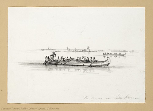 |
| "The Canoe on Lake Huron" by Anna Jameson |
And in the next paragraphs of her book Anna Brownell Jameson wrote:
“Leaving behind this cape and river, we came again upon lovely groups of Elysian islands, channels winding among rocks and foliage, and more fields of water-lilies. In passing through a beautiful channel, I had an opportunity of seeing the manner in which an Indian communicates with his friends when en route. A branch was so arranged as to project far across the water and catch the eye: in a cleft at the extremity a piece of birch bark was stuck with some hieroglyphic marks scratched with red ochre, of which we could make nothing—one figure, I thought, represented a fish.”
Perhaps by “Elysian Islands” the author meant the Bustard Islands, although there are so many beautiful islands everywhere and all of them deserve this idyllic name. And whereas Indians no longer communicate the way she described, I believe that this area has not changed that much since her visit in 1837—and I sincerely hope it will remain unaltered 170 years later.
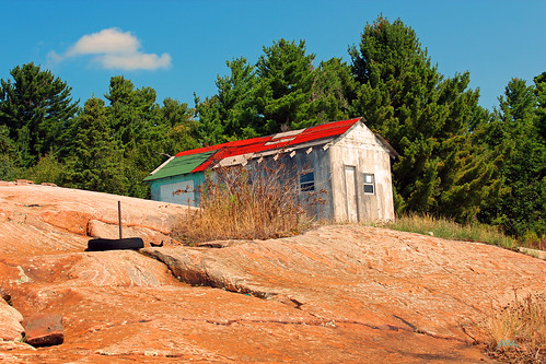 |
| Probably it used to be an old fishing shack |
We paddled south and stopped at Eastern Outlet; several cottages dotted the shores. Catherine went ashore and checked out one of them—it was probably an old fishing shack. There was an old rusty windmill on the shore. By the way, oftentimes cottages have unlocked doors, in case somebody needs to take shelter inside—some even have a posted note asking not to make any damage. Several years ago I met a fisherman in Temagami and he told me that once, as he was fishing on Lake Temagami, the weather became so bad that he had spent two nights in some cottage. Next we paddled south between Dokis Island on our left and an unnamed island on our right.
 |
| Everywhere rocks! |
As I mentioned before, Dokis Island was mainly crown land (there was, I believe, one private cottage) and from what we could see, there were plenty of places where we could camp. Suddenly Catherine pointed in the direction of Dokis Island—there was a black bear walking on the rocky shore—and a few seconds later we saw a small cub, following his mother! We paddled closer to the shoreline, but both bears quickly vanished, not allowing us to take even one photograph. We kept paddling along the shores of the nameless island; according to my GPS map (and my paper map), there was an isthmus that would make a nice shortcut and save us some paddling. We entered a small bay, but soon it became so shallow that we had to get out of the canoe and pull it over the shallows. While Catherine went ahead to scout around, I was just wading in the water and found an old, rusty axe head. I was wondering… maybe this axe was used by loggers over 100 years ago… or maybe it was just 10 years old! We turned back and kept paddling, passed an anchored sailboat, took a scenic passage between two islands and soon arrived at the north tip of the famous (or infamous) Dead Island…
 |
| ...and more rocks! |
Traditionally, Ojibwa buried their dead by wrapping them in birch bark or fur, sometimes along with some of their possessions, and placed up in the trees or under mounds of heavy rocks (probably one of the reasons being that it was impossible to dig graves, as the whole area was just bedrock). There are some burial sites of missionaries on Cross Island in the northern part of the French River; although the park authorities were not eager to disclose their exact location, I was shown photographs of similar graves, with rocks placed in such a way that they resembled a person. I was told there are many such burial sites along the shores of the French River, which of course makes sense. Certainly, most of thus buried individuals were victims of drowning, which unfortunately, were quite common as, surprisingly, very few people at that time knew how to swim—and supposedly it is still possible to spot such burial sites of one knows what to look for. In any case, such burial places were obviously very sacred to the Natives—and Dead Island was one of them.
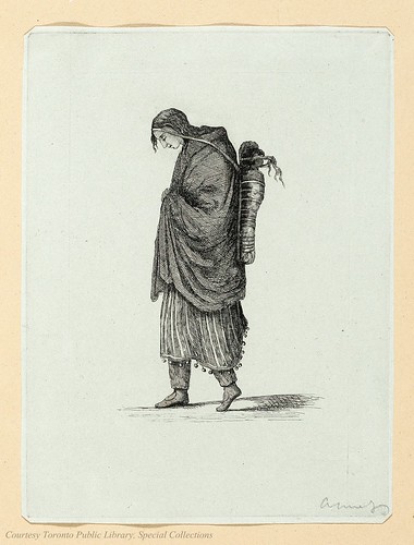 |
| "Indian Woman" by Anna B. Jameson |
In 1893 the Chicago World’s Fair was held in Chicago to celebrate the 400th anniversary of Christopher Columbus’ arrival in the New World in 1492. More than 27 million people attended the exposition during its six-month run. Its scale and grandeur far exceeded the other world fairs. The exposition was such a major event in Chicago that one of the stars on the municipal flag honors it. The exposition showed plenty of commercial attractions (especially pertaining to electricity and lighting) as well as, for the first time, a separate area of amusements was set up. Apparently one of the amusements was mummified remains of North American Indians which, coincidentally, had disappeared from Dead Island at the same time. To this day First Nations are trying to get at least some of the remains.
 |
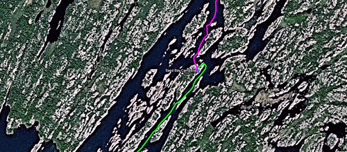
| Our route from campsite #912 to Dead Island and back |
Although I did look very hard (the island is over 1 km long, quite rocky and overgrown with vegetation), as far as I know, there were no bodies to be found on the island… Only from time to time a lonely canoeist or kayaker, who imprudently comes ashore looking for a site for overnight camping, is suddenly overcame by a strange feeling of uneasiness and discomfort that causes him to hurriedly flee, never to set his foot again on this island…
While travelling from Killarney and near the French River towards the south, Anna Jameson twice described Indian burial places:
“We passed this day two Indian sepulchres, on a point of rock, with the sparkling waters murmuring round it, and over-shadowed by birch and pine. I landed to examine them. The Indians cannot here bury their dead, there not being a sufficiency of earth to cover them from sight, but they lay the body, wrapped up carefully in bark, on the flat rock, and then cover it over with rocks and stones. This was the tomb of a woman and her child, and fragments of the ornaments and other things buried with them were still perceptible.”
And later, she describes a landing on the “Island of Skulls”:
“We landed to-day on the “Island of Skulls,” an ancient sepulchre of the Hurons. Some skulls and bones were scattered about, with the rough stones which had once been heaped over them. The spot was most wild and desolate, rising from the water edge in successive ledges of rock to a considerable height, with a few blasted gray pines here and there, round which several pair of hawks were wheeling and uttering their shrill cry. We all declared we would not dine on this ominous island, and proceeded. We doubled a remarkable cape mentioned by Henry as the Pointe aux Grondines [Alexander Henry, fur trader, merchant, militia officer and author, born in 1739, died in 1824 in Montreal, passed Pointe aux Grondines on August 31, 1761]. There is always a heavy swell here, and a perpetual sound of breakers on the rocks, whence its name [‘Grondines’ is from the French verb ‘gronder’, meaning to rumble or roar]. Only a few years ago a trader in his canoe, with sixteen people, were wrecked and lost on this spot.”
I do not know if this “Island of Skulls” is Dead Island—the author implies that after leaving the Island of Skulls, ‘we doubled a remarkable cape mentioned by Henry as the Pointe aux Grondines’. The problem is that Point Grondine lies just east of Philip Edward Island and Beaverstone Bay and it is part of Indian Reserve “Point Grondine First Nation” and in 2010 we were forced, due to a very windy weather, to spend a night camping there. Dead Island, in turn, lies about 27 km south of Point Grondine. Since Anna Jameson was travelling south, she should have passed Point Grondine FIRST and Dead Island LATER, after a few hours of paddling—unless she mixed up her timeline (which can easily happen—and I am talking from my personal experience). If anyone could provide more info on this matter, I would certainly appreciate it!
 |
| Paddling from Dead Island to our campsite # 912 |
 |
| Fortunately, the storm by-passed our campsite |
While doubling Point Grondine, Anna Jameson mentioned Henry in her book. It was Alexander Henry 'The Elder' (August 1739 – 4 April 1824), one of the leading pioneers of the British-Canadian fur trade. In 1763-64, he lived and hunted with Chief Wawatam of the Ojibwa, who had adopted him as a brother. His time with the Ojibwa and subsequent explorations are retold in his ‘Travels and Adventures in Canada and the Indian Territories between the years 1760 and 1776’ published in New York in 1809.
 |
| Alexander Henry "The Elder" (1739-1824) |
This is how Alexander Henry described his journey from Lake Nipissing, on the French River, to Lake Huron and towards Manitoulin Island (perhaps he also passed through Killarney Channel):
“The southern shores of Lake Nipisingue [Lake Nipissing] are rocky, and only thinly covered with pine trees and spruce, both, as in several instances already mentioned, of a small stature. The carrying-place of La Chaudiere Franchise is at the head of the River des Francais [French River], and where the water first descends from the level of Lake Nipisingue toward that of Lake Huron. This it does not reach till it has passed down many rapids, full of danger to the canoes and the men, after which it enters Lake Huron by several arms, flowing through each as through mill-race. The River des Francais is twenty leagues [one league was from 3.25 km to about 4.68 km] in length and has many islands in its channel. Its banks are uniformly of rock. Among the carrying-places at which we successively arrived are the Portage des Pins, or du Pin; de la Grande Faucille [‘Faucille’ means ‘a sickle’ in French], de la Petite Faucille; and du Sault du Recolet [so called, perhaps, on account of the resemblance of this Sault to that of the Sault du Recolet, between the islands of Montreal and Jesus, and which has its name from the death of a Recolet or Franciscan friar, who was there drowned]. Near the mouth of the river a meadow, called La Prairie des Francais, varies for a short space the rocky surface which so generally prevails; and on this spot we encamped and repaired our canoes. The carrying-places were now all passed, and what remained was to cross the billows of Lake Huron, which lay stretched across our horizon like an ocean. On the thirty-first day of August [1761] we entered the lake, the waves running high from the south, and breaking over numerous rocks. At first I thought the prospect alarming; but the canoes rode on the water with the ease of a sea-bird, and my apprehensions ceased. We passed Point aux Grondines, so called from the perpetual noise of the water among the rocks. Many of these rocks are sunken and not without danger when the wind, as at this time it was, is from the south. We coasted along many small islands, or rather rocks, of more or less extent, either wholly bare or very scantily covered with scrub pine trees.”
To this day I remember the waves which battered the half-sunken rocks on Beaverstone Bay (not far from Point Grondine) while we were canoeing nearby. Suddenly, a ‘rogue’ wave washed over the canoe, almost tipping it over!
 |
| Packing up and leaving our gorgeous campsite # 912 |
The next day we did not go anywhere due to strong winds and were forced to spend the whole day on the campsite—fortunately, we had a bunch of magazines to read as well as listened to the radio. We liked sitting in the shade, facing the long, narrow, rocky channel on the other side of the campsite. Catherine had locked eyes with a red fox much earlier in the morning; he decided to change course and prance off only after having sprayed our many things lying about with a skunk-like odor. In the evening I went fishing (again, I was angling in a small, weedy bay from the barren rocks in front of our campsite). In less than five minutes I caught a pike and shouted to Catherine to bring the filleting knife—and as Catherine was approaching, I cast again—and wow, another pike! In less than 20 minutes the pikes were cleaned, filleted and we had them for dinner fried up, fisherman style.
Because of the ever changing weather we did not know whether or not we should stay or return to Key Marina. On August 17, 2012 (Friday) we decided to start paddling back to the marina and spend the night either camping in Grundy Lake Provincial Park (my suggestion) or, in case of inclement weather, in a motel next to the Hungry Bear Restaurant (Catherine’s recommendation). We packed up the canoe and bid the final farewell to our site at noon. Just minutes before leaving the campsite, I spotted a small, brownish snake. I did not have a camera with me—I touched it with a stick and it lunged at it, widely opening its mouth. I had no idea what kind of snake it was, but once I arrived home, I took a look at photographs of Ontario snakes and perhaps it was Dekay’s Brownsnake (Storeria dekayi).
 |
| We were forced to spend one night here--it was a stunning site! |
It was windy, but from our campsite it did not look that bad… Well, once we started paddling, we realized the wind was much stronger than we had estimated—and of course, it was blowing against us (i.e., headwind). We were paddling very hard, but it was very tough to propel the canoe forward; when we tried to maneuver among a group of semi-submerged rocks, the wind and waves were so turbulent that we barely managed to push the canoe away from the treacherous rocks. Soon we realized that if paddling in relatively sheltered Sand Bay was so difficult, it would simply become impossible to paddle once we hit the open waters of Georgian Bay.
 |
| Although our emergency tent was small, we slept quite well |
With difficulty we reached the north tip of a very long island that ran in the middle of Sand Bay (southeast of Humbum Island) and entered into a small bay. The small hill sheltered us from the unrelenting wind. It took us over 30 minutes to paddle 1.5 km! The location was quite pleasant. I went up the hill and observed the waves on Sand Bay. There were several cottages on some of neighboring islands, but none appeared to be occupied. I spotted a few old fire pits nearby, but it was not possible to use them in this wind. Since the weather did not seem to improve, we decided to stay there overnight, using our small, emergency tent. Although I built a tiny, almost symbolic fire pit, we did not have a campfire, yet enjoyed a glass of red wine. We got into the tent very early—indeed, it was undersized (the least expensive tent from Wal-Mart that sleeps two), I could not even stretch out my legs, but overall we slept quite well.
 |
| Very short route from campsite #912 to a small bay on a long island on Sand Bay where we camped overnight |
While being ‘stranded’ on this island, I again looked at the scenery and numerous, rocky islands that were integral part of the landscape. I was wondering—did this region look identical 200 or 300 years ago? Of course, the logging industry must have wreaked havoc, clear-cutting many areas—there was not probably one pine over 100 years old standing around! Granted, trees have amazingly grown back, utilizing the very thin layer of soil and firmly attaching their roots in crevices and cracks on the rocks; perhaps they are not as tall and dense as before, but still quite impressive! And the rocky islands and shores… they have basically remained unchanged and reading the journals written hundreds years ago, I can still see the same scenery and topography described in their books… for example, let me take a look at one such explorer, Alexander Mackenzie, and his depiction of this area.
 |
| Six Alexander Mackenzie (1764-1820) |
In the late eighteenth century, Sir Alexander Mackenzie (1764-1820), a Scottish explorer crossed what is now Canada to reach the Pacific Ocean in 1793. This was the first east to west crossing of North America north of Mexico and predated the Lewis and Clark expedition by 10 years.
This is his description of the journey from Lake Nipissing, on the French River to Lake Huron and towards Lake Superior, as written in his book “Voyages from Montreal Through the Continent of North America to the Frozen and Pacific Oceans in 1789 and 1793”:
This is his description of the journey from Lake Nipissing, on the French River to Lake Huron and towards Lake Superior, as written in his book “Voyages from Montreal Through the Continent of North America to the Frozen and Pacific Oceans in 1789 and 1793”:
“In about six miles is the lake Nepisingui [Lake Nipissing], which is computed to be twelve leagues long [one league was from 3.25 km to about 4.68 km], though the route of the canoes is something more: it is about fifteen miles wide in the widest part, and bound with rocks. Its inhabitants consist of the remainder of a numerous converted tribe, called Nepisinguis of the Algonquin nation. Out of it flows the Riviere des François [French River], over rocks of a considerable height. The French River is very irregular, both as to its breadth and form, and is so interspersed with islands, that in the whole course of it the banks are seldom visible. Of its various channels, that which is generally followed by the canoes is obstructed by a number of portages. In several parts there are guts or channels, where the water flows with great velocity, which are not more than twice the breadth of a canoe. There is hardly a foot of soil to be seen from one end of the French river to the other, its banks consisting of hills of entire rock. The coast of the lake is the same, but lower, backed at some distance by high lands. The course runs through numerous islands to the North of West to the river Tessalon”.
His description could be well taken from a recent book on the French River—not much has changed for the last two hundred years!
 |
| Mornings are the best times to paddle--the water surface is mirror-like! |
We were up just after 5:00 am and of course, the wind had subsided (there was hardly ever any wind at night or in the morning). In less than one hour we were ready to go! We basically followed the same route as before and in less than 1.5 hours arrived at the Key River Lodge. Catherine went to the store and bought a few dime store candies; there were a few sluggish fishermen, leaving the marina in their motorboats. The paddle back on the Key River was very smooth—at one point we even had a back wind—a real miracle! We reached Key River Marina at 10:30 am, quickly moved our stuff to the car, strapped the canoe to the roof of my car—and drove up north on highway 69. First of all, we stopped at the Hungry Bear Restaurant, our de rigeur stopover while in the area. I had a cup of coffee and a few crackers.
We also noticed that the big map, showing the French River area, had been replaced with a different black-and-white map which we did not like at all. I remember seeing the ‘original’ map in 1995; I had taken a lot of photos with it in the background. This time we also took a few photos in front of the new map, but it was not the same… Since the two-lane, undivided highway #69 had been gradually expanding and turned into a freeway, once the construction on this stretch of the highway was completed, the Hungry Bear Restaurant would no longer be close to the highway, but a separate highway exit would have to be taken in order to reach the restaurant. I know what happened to other businesses which had been located just next to the roads that were later bypassed or made into freeways: they were, in essence, cut off from their potential customers and often very quickly closed their door forever. I sincerely hope it would not happen to this renowned restaurant which, along with the adjacent Trading Post and Motel, had been a fixture in this area for over 50 years.
We also noticed that the big map, showing the French River area, had been replaced with a different black-and-white map which we did not like at all. I remember seeing the ‘original’ map in 1995; I had taken a lot of photos with it in the background. This time we also took a few photos in front of the new map, but it was not the same… Since the two-lane, undivided highway #69 had been gradually expanding and turned into a freeway, once the construction on this stretch of the highway was completed, the Hungry Bear Restaurant would no longer be close to the highway, but a separate highway exit would have to be taken in order to reach the restaurant. I know what happened to other businesses which had been located just next to the roads that were later bypassed or made into freeways: they were, in essence, cut off from their potential customers and often very quickly closed their door forever. I sincerely hope it would not happen to this renowned restaurant which, along with the adjacent Trading Post and Motel, had been a fixture in this area for over 50 years.
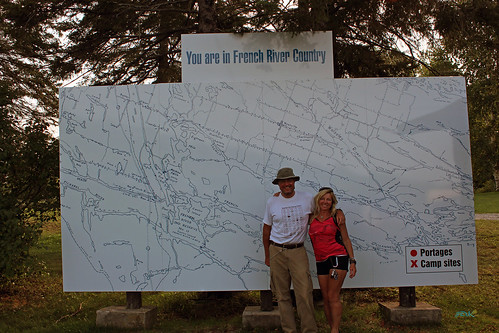 |
| The new French River map near the Hungry Bear Restaurant on highway 69 |
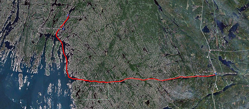
Next, we drove further north on highway 69, turned right and arrived in the town of Alban, where we went to an LCBO store (i.e., the government-operated monopoly selling hard alcoholic drinks as well as wine, beer and liqueurs in Ontario) and then to a small local supermarket called “Lemieux” (the European name certainly did not fit the image). We noticed that the butcher and his two assistants spoke French—this area had a large French-speaking population, although supposedly they had problems understanding the French language spoken in Quebec. We bought a few steaks, salad and again headed north on highway 69—our destination was the Killarney Provincial Park Office. Last year, where we went to Killarney, we simply turned left from highway 69 onto road #637 and drove for about 70 km. This time we were driving on a smooth, newly built impressive freeway and had to take a separate exit to road #637. In less than one hour we arrived at the park office where we purchased parking permits for the next 7 days (about $100-expensive!) and drove to the parking lot at the Chikanishing Creek. The weather was not very good, it seemed like it might rain—as well as it was windy, yet it was getting a little late (04:00 pm) and we did not have time to wait it out. There were a few kayakers (day-trippers) and later we had a chat with a nice gentleman who took a couple of photos of us (and chuckled under his breath). We departed at 04:30 pm, thus starting a new leg of our excursion, which I described in my next blog, http://ontario-nature.blogspot.ca/2012/08/canoeing-on-georgian-bay-south-of.html.
More photos from this trip: http://www.flickr.com/photos/jack_1962/sets/72157631846244728/
Blog in Polish/po polsku: http://ontario-nature-polish.blogspot.ca/2012/08/na-kanu-po-rzece-key-river-i-zatoce.html
Thanks for sharing, this is a fantastic blog.Really thank you! Really Great.
ReplyDeleteYou're welcome! This are is so beautiful that it's not really difficult to write a good blog... it writes itself!
Deletethere is also white timber rattlers in the french river area
ReplyDelete-and, although they don't get very long, they can get wide - and, have a rattle - and, if you get bitten by one it can be lethal - they are also venemenous - and, hog nose snake have rear fangs, & they can fold over their heads almost like a cobra - and, shot something into the air - would NOT want to get bitten by either of those two snakes
Ivan the Native Indian guide at Key Harbour Lodge for years once took a party out to French River to hike back into a trout lake. The whole party talked of a big six foot long rattle snake crossing their path. A rattler that big could only have been a timber rattler & even then anything over 55-60 inches is rare. This was back around the 1980’s.
DeleteI've read that the Timber Rattlesnake has not been seen in Ontario for over 50 years. But if I saw one, I don't think I'd be able to identify it.
DeleteThanks for your comments, but I think the Timber Rattlesnake has not been seen in Ontario since the 1950s.
ReplyDeleteLove your travel adventures!
ReplyDeleteLovely pictures & descriptions. Brings back so many memories!
We stay at a fishing camp at the mouth of the Key River.
Been going there since the late 1950's!
Years ago we had a live aboard sailboat that we took all around the North Channel in the summers prior to human overpopulation. LOVE the baby Rattlesnake!
Re: the poster above: Massassauga Rattlesnakes are the only venomous snake left in Ontario. and is threatened if not endangered by 2013. Hog Nose snakes are completely harmless, no fangs! It is a true blessing to see wildlife and still find some fish! Hope the next generations will be able to enjoy what is left of the natural world : )
Thanks for your comments. I'm sure the area has somewhat changed since the late 1950s. And I guess it was a little more difficult to sail on Georgian Bay without a GPS-I've heard a lot of stories of boats hitting rocks, it happens to even seasoned and experienced boaters. That's why I love canoeing, at least I don't have to worry about sticking to navigational routes or hitting a rock.
ReplyDeleteIn the 1950's, my parents had friends who owned a two acre island near Key Harbour. The two weeks we spent there each summer are my most enduring and pleasant memories from childhood. Your photos brought it all back quite vividly. Thank you for those, and also for the history.
ReplyDeleteMarty-you're welcome! It's a beautiful area and I hope to return there one day and paddle to the French River delta and the Bustard Islands.
ReplyDeletelove the details and history - thank-you
ReplyDeleteYou're welcome!
DeleteRan across your blog on Key River Area Of Georgian Bay. Wonderful writer & accurate account of getting to experience this area. I live in Ohio & visited this area twice a year for over 45 years. Bill Dice Georgian Bay Bass Hole.
ReplyDeleteHi Bill, I really appreciate your comments. Indeed, it's a wonderful area and each time I go there, I experience its beauty and serenity.
Delete