 |
| Lakefield, Ontario |
On my way to the park I stopped in the town of Lakefield and then drove to the site of the former farm of Susanna Moodie farm, a very well-known Canadian writer (incidentally, Catherine’s very close relatives reside nearby, on Moodie Drive) and as I was heading north, I spotted a historical plaque commemorating the 1885 dynamite explosion [N 44° 22.151 W 078° 13.454]:
 |
| Lakefield, Ontario. The site of Suzanna Moodie's farm |
1885 DYNAMITE EXPLOSION
On September 4, 1885, James Simmons and George Morton were hauling a load of dynamite from Tweed to Burleigh Falls Ontario with a horse drawn steel rimmed wagon. The dynamite was to be used for opening the Trent-Severn Lock at Burleigh Falls. They stayed overnight at a hotel in Indian River, Ontario and proceeded the next day toward Burleigh Falls via the Douro-Otonabee Township line and current Hwy# 28. At approximately 9:45 AM the area residents and the entire area were alarmed by a large dynamite explosion on Highway 28 approximately 4.1 km North of County Rd#4.
Messer's Morton and Simmons were never seen again. Ten-foot deep craters were found at the site of the explosion and the horses and wagon were found lying 50 feet on each side of the craters. Only fragments of the men, horses and wagon remained. They were described as 'mangled beyond description'. Pieces of wood and steel from the wagon were found 100 to 200 yards away.
The blast was heard in Lakefield and at distant places including Peterborough, Warsaw, Young's Point and Madoc. Large crowds soon gathered around the explosion site some searching for remnants of the victims. 'Every few minutes something more fresh and sickening befell them'. More than 1000 people and 300 carriages visited the site.
 |
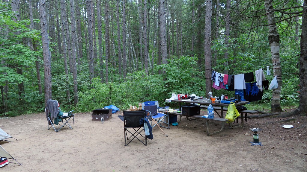
| Silent Lake Provincial Park, Ontario. Campsite number 40 |
Upon my arrival at Silent Lake Provincial Park, I set up my tent on campsite #40 [N44° 55.067' W78° 03.326']. It turned out I was the only camper in the whole campground and did not see any other campers. Over the weekend, the park became quite busy. Yet it always remained very SILENT!
 |
| Silent Lake Provincial Park, Ontario. Campsite number 40--in 2009! |
I had camped on this very campsite in 2009 with a bunch of friends from a MeetUp group; its main feature was a large rock and at that time I had several photos taken of me sitting on the rock. I decided to take similar photos again—I guess that whereas the rock had not changed much, I had!
 |
| Silent Lake Provincial Park, Ontario. Campsite number 40--in 2021! |
The weather was perfect, and there were no mosquitoes—which was quite amazing, since there were plenty of swampy areas all over the campground. There were many eye-catching mushrooms growing everywhere. I easily identified very brilliant Chicken mushrooms and Oysters mushrooms.
 |
| The Oyster Mushrooms |
Both are edible, yet I much prefer to just admire and photograph the Chicken Mushroom in the wilderness! Except for numerous chipmunks, I did not spot any raccoons or foxes. I was told there were black bear sightings this summer along the park’s trails, but not in campgrounds. On several occasions, I spotted blue jays which were curiously observing me, but later flew away.
 |
| The Chicken Mushrooms |
At night it was sometimes possible to pick up distant loon calls, but more often the very distinctive sounds made by barred owls were heard! On one occasion a barred owl must have been just meters from my tent, as the sound was so deafening (and for novices, probably scary, too) that it woke me up. Even though for years I had tried to locate barred owls by following their calls, I never succeeded—until now. As I was walking at night to the comfort station, I saw a movement between trees—it was a barred owl flying soundlessly from one tree branch to another. I shone my flashlight—and there it was, sitting on a tree branch! I even managed to take a few photographs, albeit out of focus.
 |
| The Barred Owl |
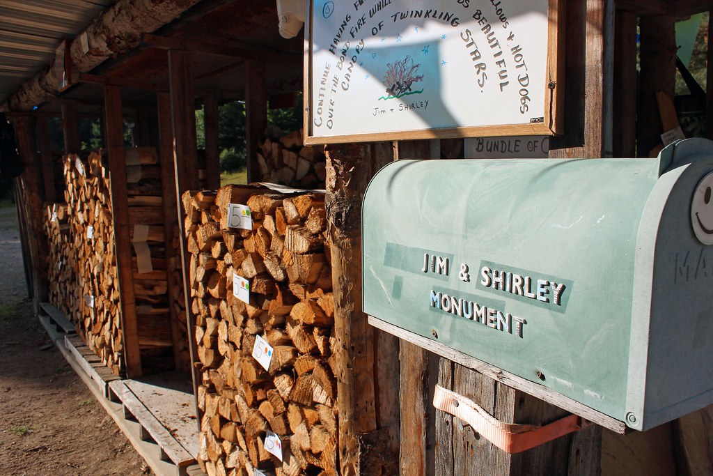
The firewood sold in parks was quite expensive. Fortunately, last year I found a place in Bancroft [N45° 05.374' W77° 52.555'] that sold firewood much cheaper and I brought so much that each night I enjoyed sitting around the fire until midnight or later.
 |
| Wood near Bancroft, Ontario--you just leave an envelope with money |
 |
| The campfire wood at my campsite-I was able to have large campfires every night! |
I always enjoy driving on various roads while staying in parks and exploring the area. One day I took Highway 28 south to Apsley, then drove east on Highway 620, reaching the hamlet of Coe Hill, which was originally settled by miners and loggers, as well as farmers.
 |
| Old Hastings Mercantile and Gallery |
In 1884, a spur line from the Central Ontario Railway was built to Ormsby, to support the newly opened iron ore mines in the area. After a while, I proceeded to the tiny settlement of Ormsby. It used to have 2 hotels, 2 stores, 2 churches and a school—and when the railway reached Ormsby, in 1893, it had a population of 225. Today its population is 20 and it is considered to be a “Ghost Town”. The main “intersection” of this settlement consists of Highway 620 and Old Hastings Colonization Road. The nearby historical plaque provides the following information:
This road was begun in 1854 as part of a network of "Colonization Roads" planned by the government to open the southern fringe of the Precambrian Shield to settlement. Under the supervision of Robert Bird, construction began at the northern boundary of Madoc Township and within a year 40 miles of summer road had been built northward to a point near present-day Bancroft. The road, when completed, was about 100 miles in length. The free-grant lots along its course were quickly taken up but poor soil prevented the development of a prosperous agricultural settlement. When the decline of lumbering in the region removed a market for produce and a source of employment, the settlers abandoned their farms and the road fell into disuse.
I was planning to drive on this road, yet there was a bridge construction, making the road temporarily impassable. On my way back, I took Highway 62 north to Bancroft and then again Highway 28 south to the park.
Inside the Old Hastings Mercantile and Gallery
Just at the corner of that crossroad was the
Old Hastings Mercantile and Gallery , located in the former Ormsby General Store, and owned and operated by Lillian Oakley Pattison and Gary Pattison [44°52'53.4"N 77°45'01.1"W / 44.881488, -77.750297].
 |
| Lillian Oakley's CD, "Seasonings". The music is wonderful! |
I had met Lillian a couple of times in Wilno, Ontario, where she ran the Wilno Craft Gallery. Approximately 19 years ago, while in the gallery, I got captivated by the music that was playing in the store—it turned out that the name of the CD was called “Seasoning” and she was the singer! I immediately bought the CD and since then I have been regularly listening to the wonderful tunes—paraphrasing the Swedish group ABBA, I should say, “Thank you for the music!”
 |
| Inside the Old Hastings Mercantile and Gallery |
Gary is also a very accomplished musician, playing the French Horn for leading Canadian orchestras. Although I cannot play any instruments (I tried to learn, but it was so hopeless), I love listening to music! It was such a pleasure to chat with Gary about his accomplishments, the French Horn, music in general and of course, the gallery itself.
 |
| Inside the Old Hastings Mercantile and Gallery |
The gallery had 11 rooms, each offering different gifts and merchandise. Exploring the rooms was akin to exploring a history museum! I was fascinated by vintage posters and postcards, books, paintings, cottage & Christmas ornaments, unique clothing, ceramics, glassware, sauces, spices, jams and thousands more original items. There was even a tiny room for children.
 |
| Inside the Old Hastings Mercantile and Gallery |
Certainly, the Old Hastings Mercantile and Gallery is a gem that should be visited while travelling in the area—and such a visit will be an unforgettable experience! Besides, after you meet Gary and Lillian, you can brag that you have personally met 10% of Ormsby’s residents!
 |
| Eagle’s Nest Park & Lookout in Bancroft |
Another place worth visiting is Eagle’s Nest Park & Lookout in Bancroft. Eagle’s Nest (Migizi Wazoson) is a special and sacred place to Algonquin people. According to interpretive signs, eagles have been present on the hilltops overlooking the York River in both a spiritual or physical sense. Eagles were very sacred to the Algonquin and it was believed that they carried prayers to the Creator and the spirit realm.
 |
| View from Eagle’s Nest Park & Lookout in Bancroft. Can you spot the Tim Horton's restaurant and a long line-up of cars? |
Thousands of years ago the entire valley seen from the top of the Eagle’s Nest was filled with water and the hilltops were just islands in the very deep water known as the Shawashkong Basin due to the melting of the Laurentide ice sheet. The York River, which can be seen below, is all that is left of the massive post-glacial drainages of ancient times.
 |
View from Eagle’s Nest Park & Lookout in Bancroft. Can you spot the small airport and eagles planes? |
There is a good, but sloping road leading to the Eagle’s Nest parking, as well as several trails from the parking lots. Reaching the lookout requires an easy hike of about 6 minutes. The view is certainly breathtaking! Unfortunately, instead of seeing Algonquins canoeing, portaging and camping throughout their territory, you can see a Tim Horton’s store and a small airport… In the fall the view must be spectacular! As to the eagles, they continued to be seen until 1918, when a young man shot an American Eagle…
 |
| View from Eagle’s Nest Park & Lookout in Bancroft |
There is also a wooden cross on top of the Eagle Nest. An inscription on the granite plaque says that the cross was dedicated by the honourable Pauline M. McGibbon, Lieutenant Governor of Ontario, on the occasion of the interdenominational Church Service Bancroft Centennial year, August 5, 1979.
 |
| Bancroft’s West Wind Gallery & Gifts |
I also visited Bancroft’s West Wind Gallery & Gifts, which had a lot of original and unique gifts and souvenirs. I especially loved a set of 4 cups with the Group of Seven paintings, which would certainly make a perfect present on any occasion.
 |
| Bancroft’s West Wind Gallery & Gifts |
While in Bancroft, quite fortuitously I went to a gallery called “A Place for the Arts” and was amazed by all the beautiful paintings and other remarkable pieces of artwork! I also spoke to the lady working there, who was very helpful and provided plenty of useful information. I wish I could have spent more time in this remarkable place. When I come to Bancroft again, it will certainly be the first place I am going to visit.
 |
| St. George's Cemetery |
I had heard before my trip that Egan Chutes Provincial Park had very scenic falls and I had planned to visit it in 2020, yet the very rainy weather caused my plans to change. This time it was on my “must-see” list!
 |
| St. George's Cemetery |
Before I was about to program my Garmin GPS, it turned out that the park had already been factory-pre-programmed and all I had to do was press “Go”. After driving on Highway 62, I turned into Old L’Amble Road and indeed, there was a parking lot, a small beach, a dock and a small dam, but no chutes of any kind! I took another look at my GPS and immediately realized that the location provided by the GPS was WRONG, and Egan Chutes Park was north from here, on Highway 28, some 25 km away! The only good thing about this was that I spotted an old burial ground, St. George's Cemetery [45°01'16.8"N 77°47'31.4"W / 45.021323, -77.792041], quite overgrown, with many old and crumbling monuments. The inscriptions on the gravestones indicated that burials took place from about the 1860s to the 1920s.
 |
| St. George's Cemetery |
After taking a bunch of photos at the cemetery, I programmed my GPS to the actual location of Egan Chutes Park and drove there. Unfortunately, once I was on Highway 28, I was unable to establish which side road I should turn into to get to the park. Eventually, I made a U-turn and again was looking for any signs. Granted, there were several side roads leading in the direction of the park, but there were no signs whatsoever. Having driven for a while, I decided to head back to Silent Lake Park, as it was getting late. I can add the actual road leading to the park is north of Highway 28, just west of L’Amable Creek: 45°04'01.3"N 77°44'11.1"W / 45.067021, -77.736423.
 |
| St. George's Cemetery |
Of course, I was quite disappointed—could not the park post a simple sign? Normally there are plenty of road signs showing directions to parks. I almost wondered if somebody had been deliberately removing such signs to prevent tourists from going to the park… However, I did find and visit the park in 2022, and I wrote about my visit in another blog.
 |
| Whetung Ojibwa Art and Craft Gallery |
On my way home I decided to re-visit an exceptional, one-of-a-kind place to shop for and admire Native art: namely, Whetung Ojibwa Art and Craft Gallery [44°27'44.5"N 78°22'18.6"W / 44.462371, -78.371832].
 |
| Whetung Ojibwa Art and Craft Gallery |
Located on the Curve Lake First Nation, the Whetung Ojibwa Center offers an astonishing assortment of Native crafts—jewelry, moccasins, masks, sculptures, paintings, dream-catchers, carvings, mugs, calendars, postcards and much, much more! All the items are truly unique and will make a perfect gift or souvenir that can be given to anyone-from friends to heads of state! In fact, exploring this gallery is akin to exploring a museum. Unfortunately, I was in a hurry and was able to spend just under one hour there, but still managed to purchase very original cards, calendars and cups featuring the works of Norval Morrisseau, Maxine Noel, Rick Beaver and Benjamin Chee Chee. One of my friends was going to celebrate her 100th birthday in October 2021, and I just found the perfect card to mail her for this exceptional anniversary.
 |
| Whetung Ojibwa Art and Craft Gallery |
I especially love the art of Benjamin Chee Chee (1944-1977), as it is so simple and minimalist, yet so powerful! About 10 years ago, while in Temagami, we paddled to Bear Island and visited the studio where Benjamin Chee Chee had once worked.
 |
| Whetung Ojibwa Art and Craft Gallery |
One of the artists whose works are featured at the gallery is Freddy Taylor. Moreover, he has a corner reserved there and usually he comes there three days a week, where he paints. He is 76 and as he said in a recent (June 2021) interview on CBC radio, “painting has brought purpose back into his life, giving him a way to heal from the trauma he experienced as a child while attending an Indian residential school in Ontario for 10 years.” I had been looking forward to meeting and talking to him, but unfortunately, he was not in the gallery that day.
 |
| Whetung Ojibwa Art and Craft Gallery. Freddy Taylor's Corner. |
