Ten days ago
(in July, 2014), while driving to Toronto back from our trip to Killarney
Provincial Park over the Canada Day holiday weekend , we had stopped near
Pointe au Baril at Payne Marina on Georgian Bay and struck up a conversation
with a couple (Mr. Rob Harris and his wife) who had just been getting their
boat ready to depart. We had asked them about canoeing and camping
possibilities in the adjacent bays—and to make the story short, they had
invited us for a 30 minute boat ride on their pontoon boat, along with their two
adorable wheaten terriers! The area was very scenic and had plenty of rocky
islands perfect for camping, yet I had been a little concerned about vast
stretches of open water we would have to paddle on. We had been very grateful
to them for this excursion and once we had arrived home, I spent several hours
studying various maps and reading books; my research soon bore fruit and on
July 13, 2014, we were on our way to a new destination, Franklin Island,
located on Georgian Bay, just north of Parry Sound.
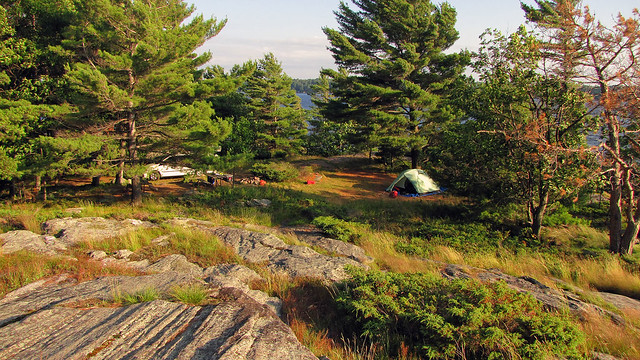 |
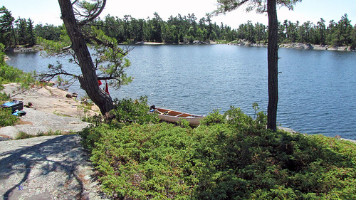
| Campsite number 1039 at Killbear Provincial Park--it was amazing! |
We stopped for
coffee at Tim Horton’s off highway 400, in King City. Once I left the car, I
immediately smelled something burning, like a metallic odor. It was one of
Catherine’s Dodge Caravan tire rim—it had become very hot and we thought
Catherine might have left her parking brake on, so we waited for a while to let
it cool off. Several weeks later her van experienced the same problem-no, it
was not due to leaving the parking brake on—she was told by the dealer that the
calipers on that model were a little small and extenders were installed to
solve the problem. Our second stop was at Parry Sound’s No Frills and Hart
Store—they had become ‘de rigueur’ places to visit while driving up north—where
we made food purchases. At Hart I bought two books that appeared to be quite
interesting: “Child 44” by Tom Rob Smith and “Enrique's Journey” by Sonia
Nazario.
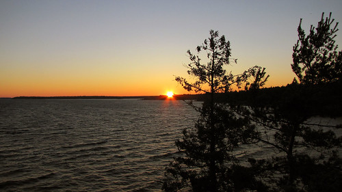 |
| We could admire an amazing sunset-right from our campsite! |
After driving
for 8 kilometers, we took exit #241 to road #559, which led to many marinas
along the coast and ended in Killbear Provincial Park. We turned right into
Snug Harbour Road and shortly after arrived at Snug Harbour. The place was not
very busy, yet once we stood on the dock, we realized it was too windy to
attempt to paddle to the island. We went to the unique restaurant (Gilly’s
Restaurant and Marina) for coffee; there was a group of kayakers who had
apparently just completed their trip. We decided to spend the night at nearby
Killbear Provincial Park and come here early next morning.
I had visited
this park for the first time in August, 1991 and stayed with a friend on
campsite #1030 for one week—I still remember that the August 1991 Soviet coup
against Gorbachev took place while I was there. Seventeen years later I camped
at Killarney over the Canada Day Long Weekend in 2008—it was a Meet-Up event
which I co-organized, we booked 4 campsites and had 24 people.
Killbear has
hundreds of campsites, some absolutely breathtaking, and they must be reserved
months in advance. Since it was Sunday and we were only spending one night at
the park, we wanted to get one of the nicer campsites.
 |
| Our campsite at Killbear Provincial Park |
As we were
driving around the park and looking for a campsite, we were shocked to see that
hundreds of trees had been cut down! The devastation was appalling, it looked
as if a tornado and hurricane had gone through this area! The reason was more
prosaic—namely, it was Beech Bark Disease, which weakens American Beech trees
and causes them to die and/or snap unexpectedly. Since the park has a
population of up to 5,000 campers and many campgrounds were located in beach
forest, the trees were in danger of falling on campsites, park roads and trails,
thus creating a huge liability for the park. So, in the fall of 2012 the park
began cutting down thousands of beech trees infected with the disease and in
many campsites tree stumps outnumbered trees.
After driving
for about 30 minutes, we decided to stay on campsite #1039, which, amazingly,
was vacant. We quickly went to the park office to get a permit—at that very
moment the last goal of the 2014 FIFA World Cup was scored and Germany defeated
Argentina 1–0 to win the tournament and secure the country's fourth world
title. The site was on the water and offered a
breathtaking view of Georgian Bay and several islands. It was quite exposed and
since it was still very windy, it took me a while to pitch the tent, but
eventually I managed to set it up and in no time we were sitting on the rocks,
just meters from the campsite, enjoying red wine and watching a spectacular
sunset as well as a very determined windsurfer who, despite several falls, kept
climbing back onto the board and continued surfing. Within minutes many campers
began to congregate around us in order to watch the sunset—unquestionably, we
had the best ‘seats’! From afar we saw Harold’s Point, which was a very popular
spot to admire sunsets. Once the sun disappeared, I got the campfire going and we
had delicious steaks. Since we had to get up early in the morning, we went to
bed and quickly fell asleep, listening to the soothing sounds of the blowing
wind.
 |
| Ready to depart towards the Snug Harbour Lighthouse! |
On Monday, July
14, 2014, we were up at 6:00 am. As I was packing up, a tame woodpecker was
relentlessly hammering a nearby tree, totally untroubled by our presence. We
also saw a few deer on the road. At the Snug Harbour dock we quickly unpacked
the van, put the canoe on the water and parked the van in a nearby designated
lot—the parking was still free (unlike the following year).
Franklin Island
was named after a famous British explorer of the Arctic, Rear Admiral Sir John
Franklin (1786-1847), who passed through Georgian Bay during his second
expedition to the Arctic in 1825. In 1845 Franklin set upon his last expedition
to find the Northwest Passage. The icebound ships were abandoned and the entire
crew of 128 perished from starvation, hypothermia, tuberculosis, lead poisoning
and scurvy. In 2015 researchers from the University of Alberta and the UK
concluded, upon examining the remains from cracked bones found on King William
Island, that the tales of cannibalism on John Franklin’s last expedition shared
among Intuit were true.
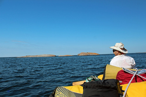 |
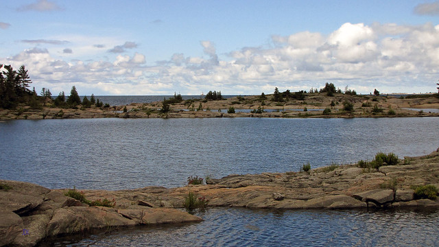
| We're on the open waters of Georgian Bay |
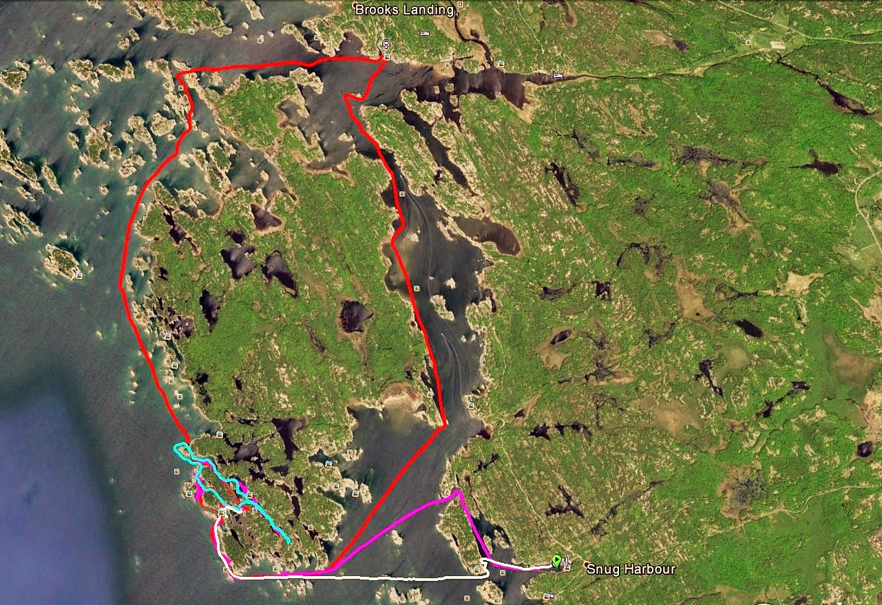
The island is
egg-shaped, with jagged shoreline, approximately 5.5 km by 3 km and there is a
channel (Shebeshekong Channel) between its east shore and the mainland, whose width
varies from just over 100 m to 2 km. Thus, getting to the island is not
difficult; considering that the prevailing winds usually blow from the west,
the east side of the island and the channel are quite protected. It is made up
of rocks, its shores are dotted with rocks, rocky islands, inlets and bays and
there are several lakes inside the island. However, the most beautiful part of
the island is facing west—i.e., the boundless waters of Georgian Bay and
the Mink Islands—and it was where we were trying to bivouac! Last, but not
least, it was still crown land and there were no fees of any kind.
 |
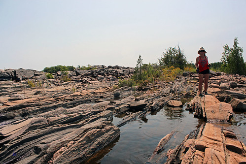
| Paddling around Franklin Island |
Instead of
padding straight towards the island, I decided to take a longer, yet more
picturesque route—before reaching the Snug Harbour Lighthouse, we turned north
and paddled along the shores of Snug Island, through a scenic channel, and once
we cleared the channel, we turned left and proceeded in the direction of
Franklin Island. Here and there were a few rocky islands, some with private
cottages. After paddling about 3 kilometers, we reached the south shore of
Franklin Island and continued between several massive rocks ominously called
Savage Rocks and the island’s shore, strewn with numerous rock formations and
inlets. Even though there was hardly any wind, we could see—and feel—powerful
tides, slowly moving up and down, probably the remnants of the recent strong
winds, as if Georgian Bay were just snoozing, always ready to wake up and show
its hidden mightiness. We reached the south-west tip of the island, Henrietta
Point, and turned right, paddling north along its west shore, manoeuvring among
massive rocky island, smaller rocks sticking out of the water as well as barely
submerged sharp rocks. We had read that many canoeists camped at Henrietta
Point; Catherine got out of the canoe and went to check it out. There were fire
pits and the place was quite big, allowing for a sizable group to set up a
camp—too big for us, we decided, and kept paddling further north.
Less than ten minutes later we spotted an entrance to a scenic bay, then we went through a passage to yet another bay, where we reached a rocky shore. The site was idyllic and quaint: there were a few sheltered bays between the campsite and Georgian Bay, where we could paddle even in very windy conditions; on the other (eastern) side there were other inlets, separated from the other bays by a very narrow rock (over which we later portaged the canoe) and they were also accessible through a channel from Georgian Bay. Several yachts and cruisers moored there overnight, but we did not even see them from the campsite. In addition, there were plenty of blueberry bushes everywhere and fantastic rocky formations! The next day I spotted a thunder-box (i.e., an outhouse without the house), but it was located in a low area full of water and unusable.
 |
| Our campsite |
Less than ten minutes later we spotted an entrance to a scenic bay, then we went through a passage to yet another bay, where we reached a rocky shore. The site was idyllic and quaint: there were a few sheltered bays between the campsite and Georgian Bay, where we could paddle even in very windy conditions; on the other (eastern) side there were other inlets, separated from the other bays by a very narrow rock (over which we later portaged the canoe) and they were also accessible through a channel from Georgian Bay. Several yachts and cruisers moored there overnight, but we did not even see them from the campsite. In addition, there were plenty of blueberry bushes everywhere and fantastic rocky formations! The next day I spotted a thunder-box (i.e., an outhouse without the house), but it was located in a low area full of water and unusable.
 |
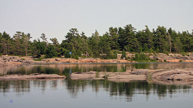
| We could see the Red Rock Lighthouse from our campsite |
So, we were sandwiched between two bays; sitting around the
fire, we had a fantastic view of the bays and the boundless waters of Georgian
Bay. Just across from our campsite, some 5.5 km. away, emerged the massive
shape of the Red Rock Lighthouse (equipped with a helipad), which emitted light
every 10 seconds. In the north we saw the Mink Islands, stretching for about 10
kilometres—they were very gorgeous and often kayakers camped there, some
islands were private and had cottages. We mulled over paddling there, but were
afraid of unanticipated changes in the weather—there was nothing between our
island and the Mink Islands and we would have to paddle for 5-6 km on totally
open and unsheltered waters of Georgian Bay—even a relatively light wind could
jeopardize our canoe and/or make it impossible for us to return to the
campsite.
 |
| Amazing view from our campiste! |
Since it was
sometimes raining, I was reading the two books I had picked up at Hart. They
were absolutely awesome and I got so engrossed in them that I seemed to forget
where I was. “Child 44” masterfully recreated the intricacies of the barbarous,
idiotic and senseless Soviet system in the 1950s, just before and after
Stalin's death. “Enrique's Journey” was about a 17 year old boy from Honduras
who travelled from his country via Mexico to the United States to be reunited
with his mother. Both books received various awards and they certainly lived up
to their glowing reviews!
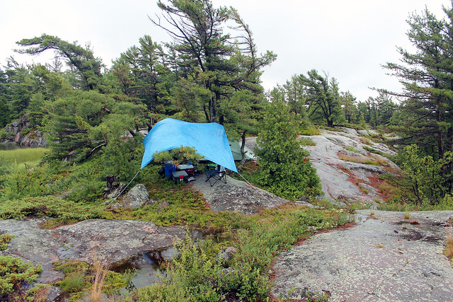 |
| The tarp and the tent |
Frustrating for
Catherine, several yachts were moored in our area with incessantly barking dogs
and noisy zodiacs which liked to zoom around our campsite.
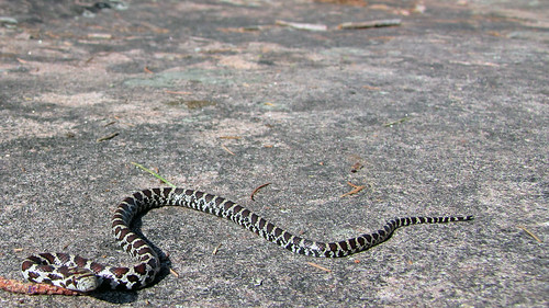 |
| Rattlesnake or Fox Snake |
One morning
Catherine left the tent, barefoot, and as I was about to follow, I saw a small
snake; she must have missed it by a hair! At that time we thought it was a
'baby' rattlesnake (Eastern Massasauga Rattlesnake), but once I came home and
examined various photographs of snakes, I was not so sure, it might have been a
small non-venomous Eastern Fox Snake as well. Interestingly, small rattlesnakes
are more dangerous than adult ones as they are unable to control to amount of
venom they inject! The snake was very small and if it was a rattlesnake, it had
not even developed a second ring. Although it was incessantly shaking its tail
(fox snakes do the same), it produced no noise. I gently put it into a paper
coffee cup—then we could hear the rattling against the cup’s walls—and released
it away from the tent. I also saw another snake near the fire pit, quite big,
but it was only a harmless and common Garter Snake—and while canoeing, we
spotted a big water snake, sun tanning on a rock, as well as a few families of
goose and ducks with clumsy goslings and ducklings. Even though black bears
could easily swim to the island, we did not see any. At night I set up a motion
video camera near our cooler, but the only animal that I caught on tape was a
benign mouse. One evening, while sitting around the fire, I heard something and
shone the light in that direction—all I could see was a pair of glowing eyes.
From time to time we observed a lonely muskrat in the bay, it must have had his
home nearby. One day, while canoeing, we saw something absolutely exceptional—a
bald eagle! It was flying relatively low over our canoe. I do not think I had
seen a bald eagle in the wild before.
 |
| At our campsite-the view was awesome! |
There was one
thing we really wanted to do—namely, to circumnavigate the island! I was
religiously monitoring marine weather forecasts (which were mostly correct,
with one exception). Unfortunately, it was quite windy during our stay and we
could only paddle in the bays; when one
day we ventured to paddle just several meters into Georgian Bay, the waves
tossed our canoe left and right so much that we immediately turned back and we
happy that nothing happened to us. Finally the wind subsided and in the morning
and we embarked on this day-long jaunt. I was glad I had my GPS unit—there were
so many islands and rocks!
We saw a few cottages here and there, even spoke to some cottagers on Dick Island—then we paddled through an opening between rocks and proceeded to Dillon’s Cove Marina and Resort, where we had ice cream from the cute 1950s retro style soda shop and fries from the chip wagon on site. The view from the restaurant was spectacular! After one hour we left the marine and paddled south in the straits between Franklin Island and Narrows Island; there were quite a few motorboats and of course, we could see many building on the mainland, we were glad we were camping on the other side of the island, where we hardly saw anybody! Altogether we paddled 18 kilometers and were very glad we were able to accomplish this!
 |
| Everywhere rocks! |
We saw a few cottages here and there, even spoke to some cottagers on Dick Island—then we paddled through an opening between rocks and proceeded to Dillon’s Cove Marina and Resort, where we had ice cream from the cute 1950s retro style soda shop and fries from the chip wagon on site. The view from the restaurant was spectacular! After one hour we left the marine and paddled south in the straits between Franklin Island and Narrows Island; there were quite a few motorboats and of course, we could see many building on the mainland, we were glad we were camping on the other side of the island, where we hardly saw anybody! Altogether we paddled 18 kilometers and were very glad we were able to accomplish this!
 |
| Our campsite |
On Friday, July 19, 2014, we packed up and bid
farewell to the island and our wonderful campsite. It was calm and we slowly
reached the picturesque Snug Harbour Lighthouse and then the dock. Thank
goodness, it was not a madhouse of loading and unloading…at least not yet. On
our way back to Toronto we stopped at Parry Sound near the train trestle, where
we had lunch near the lake. It was a beautiful evening; we drove to the
impressive Charles W. Stockey Centre for the Performing Arts. It housed a 480
seat Festival Performance Hall and the Bobby Orr Hall of Fame. It sits on a
waterfront site overlooking Georgian Bay. There was a performance going on, yet
we were able to walk in the lobby as well as admire the sunset. Reluctantly, we
then drove back to Toronto, promising to return the next year!
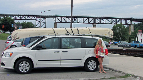 |
| Catherine, her van and our canoe in Perry Sound
Blog
po polsku/Blog in the Polish language: http://ontario-nature-polish.blogspot.ca/2015/11/biwakowanie-i-pywanie-na-kanu-dookoa.html
|
COOL!
ReplyDelete